
CIBOLA COUNTY, N.M. – As December begins, Cibola County remains firmly in drought, despite a relatively wet October and scattered fall storms.
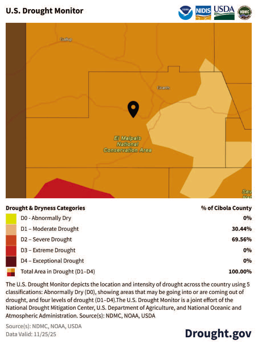
According to the latest data from NOAA and the U.S. Drought Monitor, all 27,213 residents of Cibola County are currently affected by drought. That figure has not changed from last week or last month, and the overall drought footprint has held steady as well: every acre of Cibola County is classified in at least Moderate Drought, and most of the county remains in Severe Drought.
The Nov. 25 U.S. Drought Monitor map places 30.44 percent of Cibola County in Moderate Drought (D1) and 69.56 percent in Severe Drought (D2).
There are no areas listed as Abnormally Dry or drought-free, and no part of the county is in the highest categories of Extreme (D3) or Exceptional Drought (D4). Grants, Milan and most of the El Malpais National Conservation Area fall within the D2 band, a level associated with stressed rangeland, reduced forage, declining stock ponds and smaller wells, and an elevated risk of wildfires.
Just beyond the county line to the southwest, the map shows pockets of Extreme and Exceptional drought, this is where the broader drought remains.
Recent precipitation statistics paint a nuanced picture. NOAA ranks October 2025 as the 26th wettest October in the past 131 years for Cibola County, with rainfall coming in about 0.58 inches above the long-term average for the month. However, the year as a whole remains dry. From January through October, Cibola County has experienced its 39th driest year-to-date period on record, running 1.86 inches below normal. One comparatively wet month has not erased nearly two inches of deficit that built up earlier in the year.
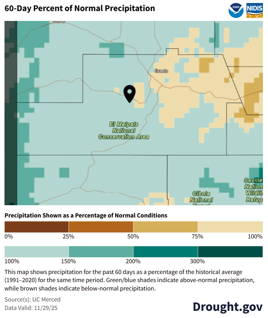
Maps from Drought.gov help explain why residents are hearing about “above-normal” rain and “severe” drought at the same time.
A 60-day percent-of-normal precipitation map valid November 29 shows much of central and south-central Cibola, including the El Malpais area, running near normal to slightly above normal for the past two months, roughly in the 100 to 150 percent of normal range. Eastern and northeastern portions of the county lean closer to or slightly below normal, closer to 75 to 100 percent of normal.
Those percentages, however, are relative to a season that is dry to begin with. For late fall around Grants, normal rainfall over a 60-day period may only amount to roughly half an inch of moisture. Getting 150 percent of that still leaves the county with less than an inch of total rainfall.
In short, “above normal” in November simply means Cibola received a little more than its usual small fall allotment, not soaking storms comparable to a strong monsoon month.
The U.S. Drought Monitor, by contrast, is designed to capture the long game. Its weekly map incorporates conditions over six to 24 months or more, looking at precipitation, deep soil moisture, streamflow, reservoir levels, vegetation health, temperature and evaporative demand. Cibola County has spent much of the past several years in one drought category or another, accumulating a substantial moisture deficit. A couple of relatively good fall months have helped stabilize conditions and prevent further rapid deterioration, but they have not refilled reservoirs or recharged groundwater.
The long-term shortfall is why the Drought Monitor still classifies nearly 70 percent of the county in Severe Drought.
Agricultural indicators highlight the on-theground impact of those classifications.
Current estimates show 448 acres of hay and 30 acres of haylage in drought conditions, along with roughly 10,281 cattle and 3,026 sheep. Those numbers represent the amount of cropland and livestock located within areas rated at least Moderate Drought.
Cibola’s surface water picture remains strained as well. A separate Cibola Water Monitoring Report in this edition takes a closer look at Bluewater Lake and the Rio San Jose, drawing on newly compiled year-long graphs from the U.S. Geological Survey.
Bluewater Lake has fallen from more than 11,000 acre-feet of storage in early 2025 to 4,608 acre-feet as of the morning of December 2. The decline was steepest through midsummer, when heat and evaporation peaked, and has slowed somewhat since August, but the overall trend remains downward.
The Rio San Jose, by comparison, has held near 1.9 feet of gage height for several months, with only brief spikes above two feet following late-summer storms. That stability is better than a collapse in flows, yet it also points to a shallow, droughtstressed river that has not seen sustained recharge.
Together, the drought maps and USGS records tell a consistent story about Cibola County’s water year: brief moments of replenishment set against a longer-term decline. Short bursts of rain and a relatively wet October have offered shortterm relief, but they have not been enough to rebuild storage at Bluewater Lake, deepen flows on the Rio San Jose or erase years of precipitation deficits.
As of early December, there has been no change in the extent or intensity of drought in Cibola County compared to last week or last month.
The absence of Extreme and Exceptional drought within county lines is a modest bright spot, but the dominance of Severe Drought continues to pressure rangeland, wildlife, domestic wells and surface water supplies. With winter just beginning and mountain snowpack still developing in the Zuni and Bluewater basins, the next several months will be critical.
Snow accumulation and late-winter storms will determine how much relief flows into Bluewater Lake, the Rio San Jose and the broader watershed in 2026.