Cibola’s Skies Still Cloudy, Staying Cool with Intense Pressure System
GRANTS, N.M. – Cibola County is preparing to experience heat like its neighbors across the Southwest United States. While neighbor states bake under extreme heat, Cibola has enjoyed significant cloud coverage and decent rainfall spurred on by the monsoon season.
A large heat dome is making its way ever westward, baking portions of New Mexico, Colorado, Arizona, Utah, Nevada and California. Yet, Cibola has managed to avoid the heat and maintain the monsoon rains, despite the odds.
Scientists with AccuWeather and the National Weather Service expected Cibola to see significant heat, like many of New Mexico’s neighbors. Most of New Mexico has defied the expectations of weather scientists and has remained relatively cool with continued rainfall, officials are split on how long this will last.
A pressure system has built in New Mexico thanks to the strength of the recent monsoons, according to the National Weather Service. This system is allowing New Mexico, and the southcentral portion of Colorado, to stay cool while NM’s neighbors in Arizona and Utah experience triple digit temperatures.
In the meantime, the National Weather Service wrote on July 12, “Daily rounds of showers and thunderstorms will continue for the foreseeable future as will the threat for flash flooding, especially on burn scars. With an area of high pressure stuck over the area, these storm motions will be slow and erratic which will only contribute to the flash flooding threat. Otherwise, temperatures will be near normal for most except perhaps a few degrees above normal across the eastern plains.”
The heat dome is latching on to the Four Corner’s Region in the Southwest, researchers have no expectations on when it will release its grip over the region. New Mexico’s pressure system has been working to keep the state cool as the intense heat has been building up, sending temperatures in Phoenix, Arizona, upwards of 115 degrees Fahrenheit on July 11. The localized pressure system appears to be keeping heat at bay for the moment, with the National Weather Service writing, “Little change in the overall weather pattern is expected through the long-term period as the H5 high that builds over the Four Corners Wednesday becomes the dominant feature across the western [Continental United States]. Despite this strong high pressure over the area, there is no influx of drier air to scour out the moisture. Thus, we`ll be in recycle mode for several days with very similar weather conditions each day. Thunderstorms will first develop over the high terrain by mid-day before becoming more scattered in coverage across central and western NM through the evening hours with more isolated coverage across the east. Thanks to the H5 high`s presence, storm motions will be slow and erratic, and these slow storm motions will only contribute to the risk for flash flooding, especially on the burn scars.”
Weather scientists are expecting the localized pressure system to remain and shield New Mexicans from the intense heat, with rainfall staying in the forecast for the foreseeable future.
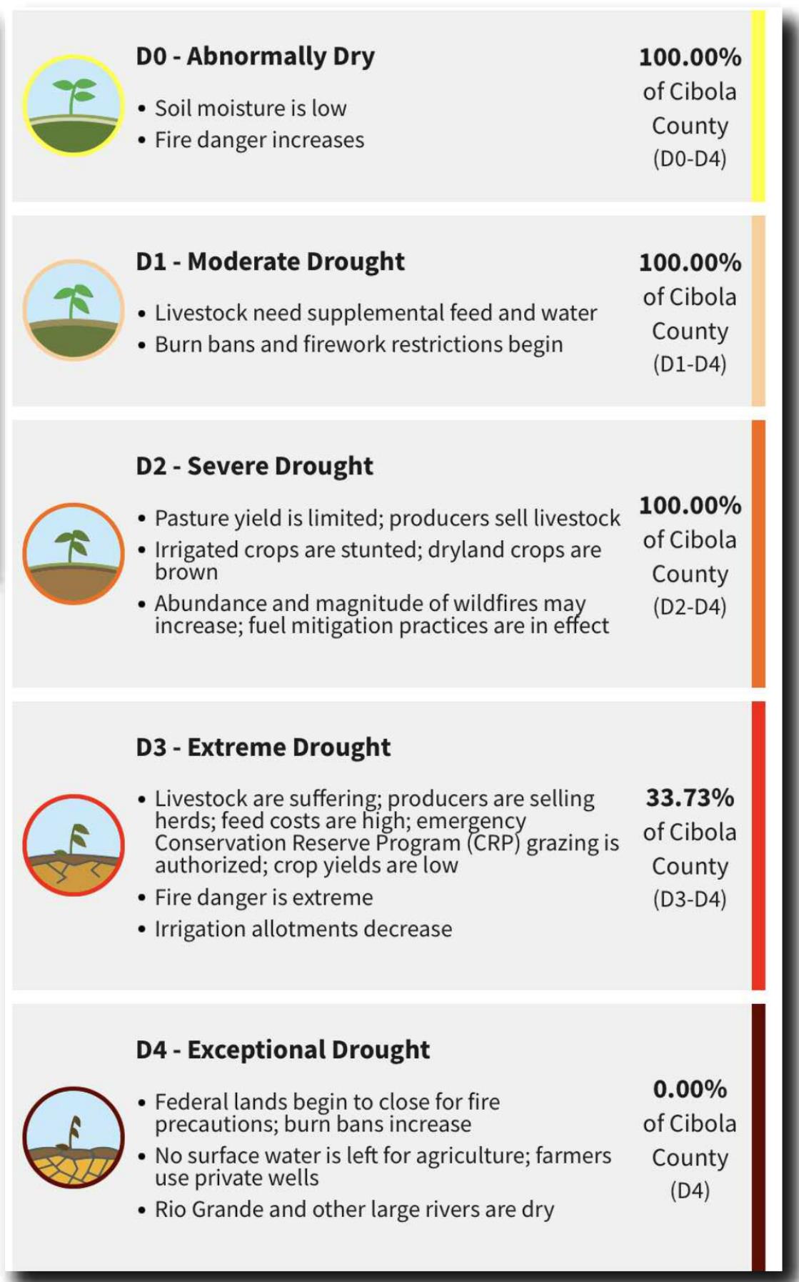
Recent heat has helped with the intense drought Cibola has been suffering through, after May 2022 came up as the driest May in area history since tracking began 128 years ago. With no rain in May, parts of Cibola were experiencing “Exceptional Drought,” the highest drought designation used by the US government. As of July 12, no part of Cibola is in this rating, but one third of Cibola is still experiencing “Extreme Drought” and 100 percent of Cibola is affected by “Severe Drought.”