Halfway through the year, extreme drought covers nearly all of Cibola County
CIBOLA COUNTY, N.M. – Halfway through 2026, Cibola County’s drought story has become one of persistence, escalation and waiting.
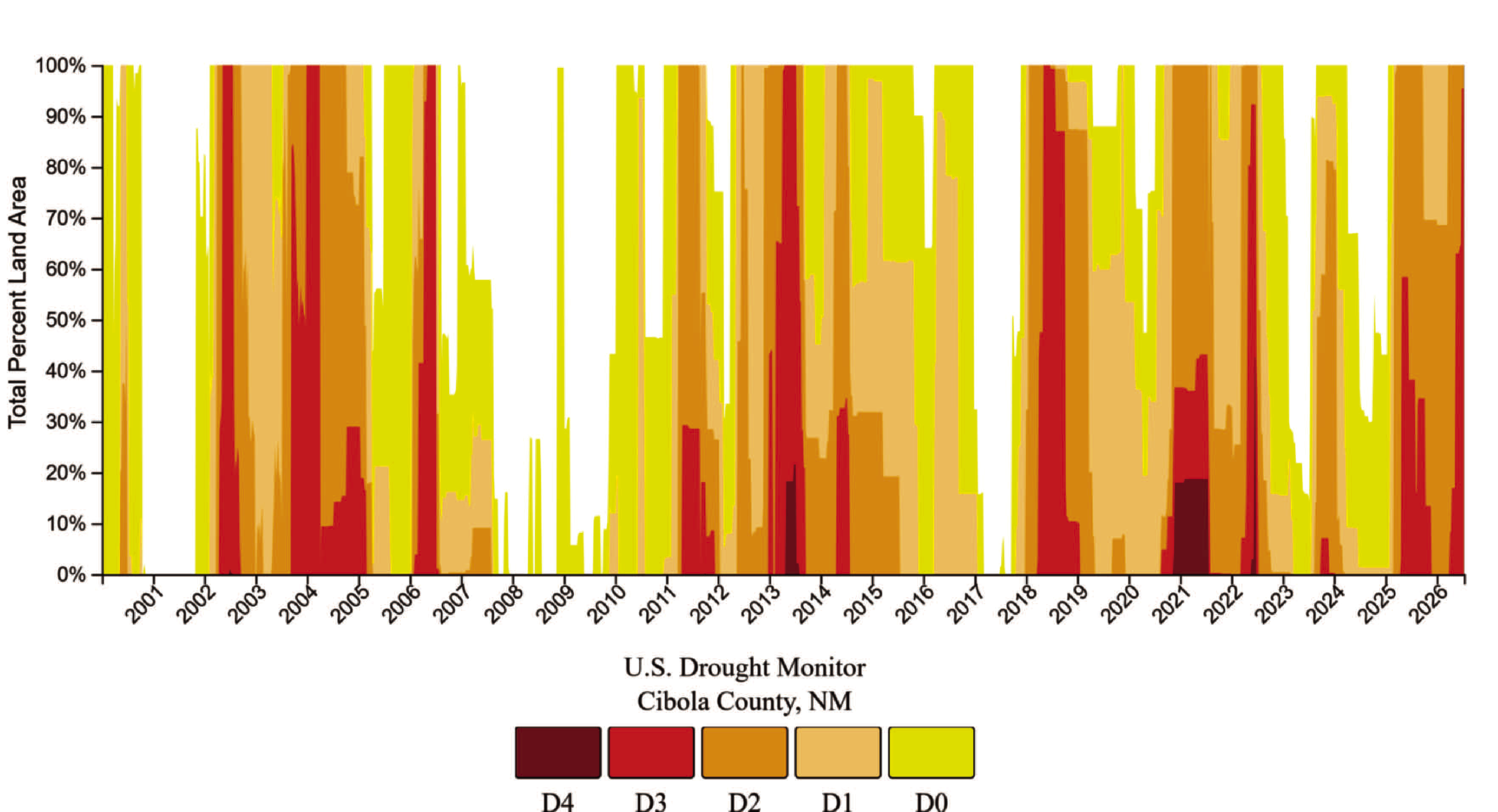
The county has now officially spent the first six months of the year entirely in drought. According to NIDIS data retrieved July 21, 27,213 people in Cibola County – 100% of the county’s population – remain affected by drought, with no change from the previous week or month.
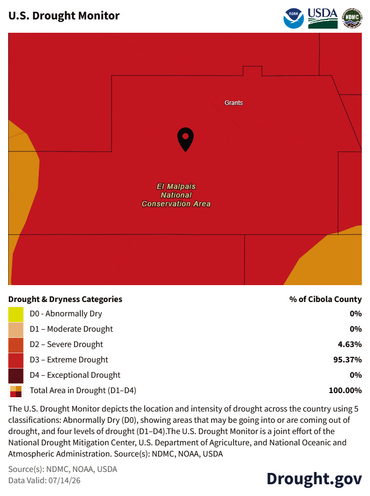
But the intensity of that drought has shifted sharply since winter. Extreme Drought, or D3, now covers 95.37% of Cibola County, while Severe Drought, or D2, covers the remaining 4.63%. No part of the county is listed as drought-free, abnormally dry or in only moderate drought.
In January, the county was fully in drought, but the map was split between moderate and severe drought. By May, extreme drought had expanded across most of the county. By June, extreme drought covered nearly all of it.
Federal climate rankings show June 2026 was the 57th driest June in the past 132 years, finishing 0.26 inches below normal. For the year so far, January through June ranked as the 29th driest start to a year in the 132-year record, with precipitation running 1.72 inches below normal.
Those numbers help explain why recent scattered moisture has not translated into meaningful recovery. A storm can cool an afternoon, wet a road or briefly green up a field, but Cibola County entered June carrying the effects of a weak winter snowpack, limited spring runoff and months of accumulated precipitation deficit. By the time summer heat arrived, the county was already behind.
That pattern has shown clearly at Bluewater Lake.
The lake measured 7,366.39 feet in elevation on June 2, then dropped to 7,366.19 feet on June 9, 7,366.02 feet on June 16 and 7,365.78 feet on June 23. The decline from June 16 to June 23 — roughly a quarter foot — was one of the larger weekly drops observed during the month.
The weekly changes are not dramatic in isolation, but the six-month trend is unmistakable. Bluewater Lake has continued to lose elevation because the winter snowpack did not produce significant spring runoff, spring precipitation remained inconsistent and warmer temperatures increased evaporation as summer approached.
The reservoir has not shown the kind of sustained rebound that would suggest the watershed has turned a corner.
The Rio San Jose has told a different but related story.
At the Acoma Pueblo gauge, the river measured 1.92 feet on June 2 and June 9, then held near 1.91 feet on June 16 and June 23. The river has remained remarkably stable through much of 2026, generally fluctuating only a few hundredths of a foot from week to week.
The Rio San Jose water gauge continues to reflect modest base flow in a watershed still shaped by drought.
June also brought signs that the atmosphere may be trying to shift toward a more active summer pattern. Several Drought.gov precipitation maps showed pockets of improvement compared with the driest parts of spring. Some southern and southeastern areas of Cibola County received closer to normal, or even above-normal, precipitation over recent 30-day windows. Forecasts late in the month showed better chances for light-to-moderate rainfall, with much of the county expected to receive between one-tenth and one-half inch through the end of June, and isolated locations potentially receiving more if thunderstorms developed.
Still, the improvement has been uneven. Areas north and west of Grants continued to lag behind normal precipitation levels, and many weekly precipitation maps continued to show large portions of the Grants and El Malpais area receiving only trace amounts to light rainfall. The county has seen pockets of moisture, but not a widespread wet pattern.
Heat has made that uneven moisture less effective.
During June, average daytime highs across the Grants and El Malpais area frequently ran in the 80s to low 90s. In mid-June, Drought.gov data showed highs running roughly 4 to 6 degrees above normal across much of the county. Abovenormal heat increases evaporation from reservoirs and soils and accelerates the drying of grasses, brush and other vegetation. In a wet year, that kind of heat is part of summer. In a drought year, it puts more pressure on everything.
That pressure is now showing up across the fire landscape.
During June, fire restrictions tightened across Cibola County and on nearby public lands. The Mt. Taylor Ranger District moved into Stage II Fire Restrictions beginning June 18, and the National Park Service implemented Stage II restrictions at El Malpais and El Morro national monuments beginning June 22. The Village of Milan also enacted restrictions effective June 16, while Cibola County continued under burn restrictions affecting unincorporated areas.
The restrictions differ by jurisdiction, but the reason behind them is the same: dry fuels, heat, wind and human activity create conditions where a small ignition can become a fast-moving fire.
June also brought several reminders of how quickly fire can appear in a dry landscape.
The Seco Fire, reported May 27 in the southeast Mount Taylor Mountains, was held to less than one acre after firefighters quickly stopped its forward progress. The Hausner Fire, reported June 8 in the Zuni Mountains, was caused by lightning and estimated at about two acres before being extinguished. Both fires remained small, but they occurred against a backdrop of worsening drought, dry fuels and increasing restrictions.
The fact that those fires were controlled quickly is good news. The fact that they occurred at all is part of the larger June story. As thunderstorm activity increases, lightning can bring both the moisture the county needs and the ignitions firefighters have to chase. That is the difficult balance of early monsoon season in a drought year.
Statewide forest health data adds another layer to the same picture.
A New Mexico Forestry Division and U.S. Forest Service survey found that tree deaths tripled across New Mexico in 2025 during a year marked by drought and heat. Forests impacted by drought and heat increased 66%, and beetlekilled conifer forest increased sharply, mostly on national forest lands. The report is statewide, not limited to Cibola County, but it reinforces what local water and fire data have already shown: prolonged drought affects forests, fuels, watersheds and the work people do on the land.
Agriculture remains inside the drought footprint as well.
Federal estimates continue to place 448 acres of hay and 30 acres of haylage in drought conditions in Cibola County, along with an estimated 10,281 cattle and 3,026 sheep. Those figures do not mean every producer is affected the same way, but they show how broad the drought footprint remains across the county’s working landscape.
The June drought report lands at a turning point in the year.
The winter snowpack season is gone. The spring recharge window did not deliver. Bluewater Lake continues to decline. The Rio San Jose remains steady but modest. Fire restrictions are now part of the summer reality. And nearly all of Cibola County is now classified in Extreme Drought.
At the same time, June began to show hints of the next possible source of relief. The county is moving toward monsoon season, and forecasts late in the month suggested better chances for scattered rainfall than many of the dry weeks earlier this year. But scattered storms will not be enough by themselves. Meaningful improvement will require repeated, widespread rainfall that reaches more than isolated pockets.
For now, Cibola County is caught between drought that has already deepened and the hope that summer moisture can still slow the damage. Six months into 2026, drought remains one of the defining stories of the year.
Data sources used in this report: NIDIS and U.S. Drought Monitor county drought statistics; NOAA climate rankings for June and year-to-date precipitation; U.S. Geological Survey data for Bluewater Lake and the Rio San Jose at Acoma Pueblo; Drought.gov temperature and precipitation maps; Cibola Citizen water monitoring reports published June 3, June 10, June 17 and June 24; Cibola Citizen fire coverage; U.S. Forest Service and National Park Service fire restriction notices; New Mexico Forestry Division and U.S. Forest Service forest health survey information.