
Heavy September rainfall forecast as Bluewater Lake continues to decline
CIBOLA COUNTY, N.M. – A major surge of monsoon moisture is arriving in Cibola County after another week of declining water levels at Bluewater Lake and the Rio San Jose, setting up an important test of how September rainfall will affect local water conditions. Forecast maps show several inches of precipitation possible across portions of the county through Sept. 21, while the latest USGS measurements provide a snapshot of conditions just before the wetter pattern intensified. Bluewater Lake
According to provisional U.S. Geological Survey data, Bluewater Lake contained 3,020 acre-feet of water Tuesday morning, Sept. 15, down from 3,054 acre-feet on Sept. 8.
That is a decrease of 34 acre-feet, or about 1.1%, during the week.
The decline continues a pattern seen through summer 2026: despite periods of substantial monsoon rainfall across Cibola County, Bluewater Lake has continued to lose water.
Rio San Jose
The Rio San Jose at Acoma Pueblo measured 1.96 feet Tuesday morning, according to provisional USGS data.
That is down slightly from 1.98 feet on Sept. 8, a decrease of 0.02 feet.
The change is small, but it means both of the water measurements tracked by the Citizen were lower at the beginning of this week's significant rainfall event.
Precipitation Across Cibola
Drought.gov data valid through Sept. 12 show precipitation during the last seven days was uneven across Cibola County. Much of the Grants area received relatively light precipitation, while higher totals were recorded farther south and southwest, including portions of the El Malpais region.
Temperatures were also warm. Seven-day average maximum temperatures generally ranged through the 80s across much of the county, with portions of the region running several degrees warmer than the 19912020 average.
Conditions changed substantially Monday as a strong surge of monsoon moisture reached western New Mexico. Rain was already falling in Grants Monday morning, and widespread showers and thunderstorms continued developing Tuesday.
The National Weather Service expects the wet pattern to expand Wednesday and Thursday, with periods of moderate to heavy rainfall. Stronger storms Wednesday could produce rainfall rates exceeding 2 inches per hour, creating a risk of flash flooding where storms repeatedly pass over the same locations.
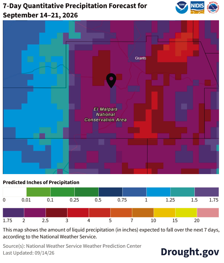
The seven-day precipitation forecast illustrates just how different the coming week could be from the previous one. The Weather Prediction Center forecast issued Sept. 14 shows roughly 2 to 4 inches of precipitation possible across broad portions of Cibola County through Sept. 21, with the heaviest projected totals concentrated in parts of central and eastern Cibola County.
Those amounts are forecasts, not guaranteed rainfall totals, and monsoon precipitation can vary substantially over short distances.
Arroyos, low-water crossings, burn scars and other flood-prone areas will remain particularly vulnerable through the wetter pattern.
Water data courtesy of the United States Geological Survey. Temperature, precipitation and drought information courtesy of Drought.gov, the National Weather Service, the U.S. Drought Monitor, the Climate Prediction Center and the New Mexico Environment Department.
A seven-day precipitation forecast issued by the National Weather Service Weather Prediction Center shows significant rainfall expected across Cibola County from Sept. 14-21. Much of the county is forecast to receive roughly 2 to 4 inches, with locally higher amounts possible. Forecast rainfall totals can vary considerably, particularly with thunderstorms.