CIBOLA COUNTY Experiencing its 23rd driest March on record, the drought situation in Cibola has seen mixed changes throughout the county since February. The percentage of land under drought decreased in March, but the number of livestock affected remained the same.
The March report was delayed due to technical issues at the National Oceanic and Atmospheric Administration (NOAA), which affected the timely release of the necessary data. These technical issues have also delayed the April Drought Monitor which is scheduled to be published in the June 5 edition of the Cibola Citizen.
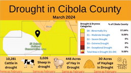
Drought Across Cibola in March
The U.S. Drought Monitor classifies the severity of drought using five categories, ranging from the least severe designation, 'Abnormally Dry' (D0), to the most severe, 'Exceptional Drought' (D4).
• Abnormally Dry (D0) - 57.60 percent of Cibola is affected, a large increase from February when 44.1 percent of the county was affected. The area extends from the northwest, cutting through the southeast, expanding from east of Fence Lake through the Pueblo of Laguna to the east.
• Moderate Drought (D1) – 9.23 percent of Cibola is affected, a significant decrease from February when 55.41 percent of the county was affected.
• Severe Drought (D2) – Zero percent of the county is affected, a continuation from February and January, where no areas were recorded.
• Extreme Drought (D3) - No areas recorded, the same as in February and January.
• Exceptional Drought (D4) - No areas recorded, the same as in February and January.
Impact on Agriculture
In March, 448 acres of hay were found to be in drought, a substantial increase from the 250 acres affected in February. The acreage of haylage remained constant at 30 acres, indicating no change from the previous month. This increase in drought-affected hay acreage highlights a worsening situation for Cibola’s agricultural resources.
Effecting livestock, 10,281 cattle and 3,026 sheep were found to be in drought during March. This is the same number of livestock affected as in February, showing no change in the situation for Cibola’s livestock.
Through March, Cibola experienced a slight increase in drought coverage, with 66.83 percent of its total area affected. This marks a rise compared to February, where 55.9 percent of the county's total area was in drought.
The parts of Cibola unaffected by abnormal dryness form a large circular area in the west, encompassing the regions of Ramah Navajo, Fence Lake, Zuni Pueblo, and Techado.
Historical Context and Data Sources
The National Integrated Drought Information System (NIDIS) is a tool used by the National Oceanic and Atmospheric Administration (NOAA), which has been tracking drought in the Cibola area since 2006. They use historical data and environmental sampling to get a drought reading on years prior, extending back to 1894, providing 300 years of data.
Much of the data utilized by the Cibola Citizen comes from NIDIS, NOAA, the U.S. Department of Agriculture (USDA), and the National Agricultural Statistics Service (NASS). These entities supply data for Cibola’s acreage of hay and the number of livestock affected by drought.