
Late-September Rainfall Leaves Its Mark As New Water Year Begins
CIBOLA COUNTY, N.M. – Cibola County's exceptionally wet finish to the 2026 monsoon season left a measurable mark on local waterways, but the first readings of October show how quickly some of that response can fade.
The Rio San Jose has returned near its pre-storm level after surging above 4 feet during heavy rainfall Sept. 28, while Bluewater Lake has held onto most of the modest increase recorded following the storms.
Bluewater Lake
According to provisional U.S. Geological Survey data, Bluewater Lake stood at 7,364.23 feet Oct. 6, down slightly from 7,364.27 feet Sept. 29.
The 0.04-foot decline amounts to about half an inch. Despite the decrease, the lake remains above its Sept. 22 reading of 7,364.15 feet, before the late-September storms produced the first weekly increase after an extended period of decline.
Rio San Jose
The Rio San Jose at Acoma Pueblo measured 1.91 feet Tuesday, down from 2.51 feet Sept. 29.
That continues a rapid retreat from the river's storm-driven surge. USGS data recorded the Rio San Jose at 4.32 feet late Sept. 28 as heavy rainfall and runoff moved through the watershed.
The river's rise and subsequent decline illustrate how quickly stream conditions can change during and after heavy rainfall.
Zuni Mountain Precipitation
A new water year began Oct. 1, resetting the precipitation measurement at the Rice Park SNOTEL station in the Zuni/Bluewater River Basin.
Rice Park finished September with 17 inches of water-year precipitation, or 87% of its median of 19.6 inches. Its cumulative precipitation reading has now reset to zero for Water Year 2027.
The station also reported 0.2 inches of snow water equivalent Oct. 6, providing an early starting point as the Water Monitor begins tracking the coming winter season.
Precipitation Across Cibola
The final days of September brought widespread rainfall across Cibola County.
The latest seven-day precipitation map shows roughly 1 to 2 inches across much of the county, with higher totals in some areas, following repeated storms that saturated soils and produced flooding and road impacts.
The wet weather was accompanied by cooler conditions. Seven-day average maximum temperatures were generally in the 60s across much of Cibola County.
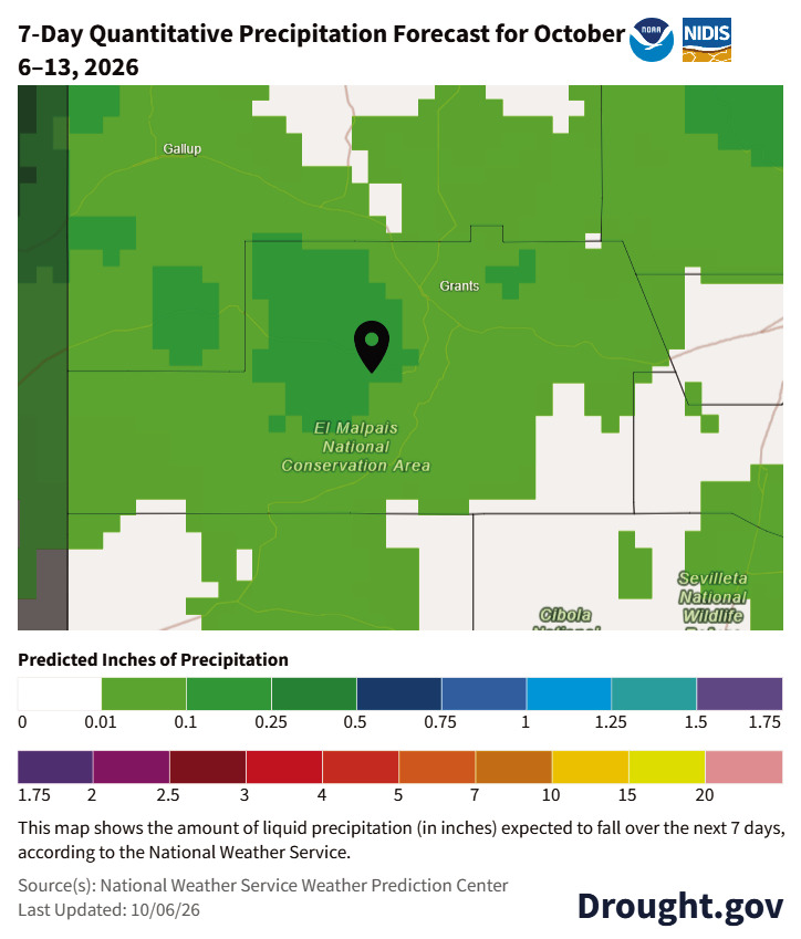
The pattern is now becoming quieter. The National Weather Service Weather Prediction Center's forecast for Oct. 6-13 generally calls for less than onehalf inch of precipitation across the county, including around one-tenth of an inch in the Grants area and somewhat higher amounts to the west and southwest.
With the traditional monsoon period over and a new water year underway, attention now turns toward fall precipitation and the development of the winter snowpack.
Water data courtesy of the United States Geological Survey. Temperature, precipitation and drought information courtesy of Drought.gov, the National Weather Service, the U.S. Drought Monitor, the Climate Prediction Center and the New Mexico Environment Department.