
New Fire Activity, Water Levels, and Warnings Ahead of Summer
Diego Lopez, Editor
Editor’s Note: This article was written on May 22, on May 23 the US Bureau of Land Management, who manages a large portion of wildland in Cibola County, issued Stage 1 Fire Restrictions for all BLM land in Cibola.
CIBOLA COUNTY, N.M. — As Memorial Day weekend arrives, fire restrictions across New Mexico are tightening, wildfire incidents continue to emerge, and the persistent drought gripping Cibola County shows no sign of loosening its hold. New data, incident reports, and federal fire orders paint a picture of a region under mounting pressure—from forest conditions and fuel moisture to community safety and agency coordination.
While two high-profile fires—the Alamo Fire on April 27 and the Cinder Cone Fire on May 11—have dominated public attention, at least three other wildfire events have sparked in the past month, including: one north of San Mateo, the La Mosca Springs Fire, which started over the weekend on May 20 and burned 0.25 acres; and another near Timberlake, known as the Laguna Mason Fire, started the same day as the Alamo Fire, burned 63 acres.
With the entire county still in drought, and nearly 60 percent of Cibola’s land classified under “Extreme Drought” (D3), local and federal agencies are bracing for what could be an exceptionally dangerous summer.
New Fires Spark Concerns
The most recent fire in Cibola County, the La Mosca Springs Fire, broke out over the weekend approximately 14.2 miles northeast of Grants on Mt. Taylor.
The fire burned 0.25 acres of oak and juniper brush before it was quickly contained by the U.S. Forest Service on May 20, with full control achieved the following day.
Although small, the incident showcases ongoing risk. Weather conditions at the time included humidity as low as six percent, gusting winds, and temperatures approaching the high 70s. These are classic fire-prone conditions, and officials say more events like this are expected.
Additionally, on the same night as the Alamo Fire in Grants—which destroyed six homes—firefighters responded to another wildfire near Timberlake. That fire, dubbed the Laguna Mason Fire, did not reach the scale of the Alamo Fire, but occurred within the same critical time window, stretching emergency response across Cibola County.
Drought Update: Still No Relief
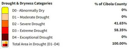
The latest report from the U.S. Drought Monitor (May 22) confirms that 100 percent of Cibola County remains in drought.
Of that, 58.35 percent is under Extreme Drought (D3), and the remaining 41.65 percent is in Severe Drought (D2).
No portion of the county has seen drought improvement for weeks.
April 2025 ranked as the 56th driest April in 131 years, with the year-to-date precipitation total coming in 1.91 inches below normal, making this the 8th driest start to a year on record for Cibola.
Impacting local agriculture, drought conditions are affecting: 448 acres of hay; 30 acres of haylage; 10,281 cattle; 3,026 sheep.
The green USDA banner that previously labeled Cibola as “Not in Drought” has now been removed from the Drought Monitor site, following weeks of confusion.
What does this mean?
At first glance, hearing that 2025 ranks as the '8th driest year to date' might not raise immediate alarm. But for Cibola County— where nearly 60 percent of the land is now in Extreme Drought (D3) and the other 40 percent in Severe Drought (D2)—this is a flashing red warning sign.
To put the crisis in context, Cibola has not experienced this degree of drought coverage and intensity since the back-to-back drought disasters of 2022 and 2023. During those years, parts of the county briefly entered the highest drought category possible— Exceptional Drought (D4). In May 2022, Cibola endured its driest May in over 300 years of historical tracking, according to federal drought scientists. That same month, the Cerro Bandera Fire ignited in the Zuni Mountains and consumed more than 900 acres.
In 2023, another Exceptional Drought designation struck in June, affecting 40 percent of the county. While these events were severe, they built gradually over several months. What sets 2025 apart is the velocity of deterioration. Cibola County jumped from roughly 50 percent drought coverage in early February to 100 percent by March 5, with Extreme Drought emerging suddenly by late April and covering more than half the county by mid-May.
This kind of rapid escalation is rare.
In fact, NIDIS drought monitors have tracked drought conditions weekly since 2000, and data analysis shows that 2025 ranks among the fastest increases in severity recorded over the past 25 years.
Snowpack in the Zuni/Bluewater River Basin has also vanished. As of May 22, the Rice Park station recorded 0.0 inches of snow depth—no spring runoff, no moisture buffer, no groundwater recharge. This, combined with 1.91 inches of precipitation deficit for the year so far, leaves the land in a dangerously flammable state. Each tree is a dry matchstick. Each field, a tinderbox.
This is no ordinary dry year.
Bluewater Lake Boating is Good, Water Levels Falling
Despite ongoing drought, boating conditions remain rated “excellent” at Bluewater Lake—though levels are trending downward. As of May 22, the lake held 8,887 acre-feet of water, down from 9,453 earlier in the month.
A USGS telemetry glitch briefly showed a sharp drop to 7,146 acre-feet on May 21, but officials confirmed there was no actual water loss. The situation showcases the importance of continued monitoring as reservoir levels decline going into summer.
Cibola at the Center of a Growing Fire Risk
Fire restrictions now cover nearly every jurisdiction in and around Cibola County, with local and federal agencies escalating measures as drought deepens and wildfire risk intensifies.
The City of Grants, Village of Milan, and Cibola County all remain under countywide burn bans, prohibiting any outdoor burning, including fire pits, yard debris, and other fires. These restrictions are in place indefinitely and violations may carry fines of up to $500 under state law.
Surrounding ranger districts have also tightened their fire rules.
On May 22, the Mountainair and Sandia Ranger Districts entered Stage 2 Fire Restrictions, banning campfires even in developed campgrounds, restricting off-road vehicle use, and prohibiting equipment like chainsaws and welding tools during peak burn hours.
The Magdalena Ranger District, south of Cibola, implemented Stage 1 restrictions the same day, further encircling the county in firelimiting orders.
At Bluewater Lake State Park, Stage 2 Fire Restrictions remain in effect through July 1, banning all fires, charcoal grills, and fireworks, while only allowing propane devices within cleared areas.
Local fire leaders are urging the public to prepare by:
• Clearing at least six feet of brush and dry vegetation around homes
• Avoiding any type of open flame
• Keeping hoses and emergency supplies ready
• Reporting any visible smoke or suspicious activity immediately
The Bottom Line
From the Alamo Fire’s destruction in Grants, to La Mosca Springs’s flare-up in Mount Taylor, to expanding drought and disappearing snowpack, the signs are clear: Cibola is in the grip of an intensifying fire season. While state and federal agencies are ramping up restrictions, the true front line lies in communities, neighborhoods, and individual households.
Preparedness is no longer optional, it’s essential.
The Cibola Citizen will continue to track wildfires, water levels, drought declarations, and burn restrictions throughout the season. For fire maps and smoke updates, visit fire.airnow.gov or nifc.gov. To view the latest drought conditions, visit drought.gov.